Coordinates are two numbers that name one spot on Earth: latitude, how far north or south it is, and longitude, how far east or west it is. If you need the coordinates of a trailhead, a meeting point, a house with no clear address, or the place you are standing right now, you can get them in under a minute. This guide covers every practical route, starting with the fastest one.
The fastest route is the Coordinate Explorer on this page: click any spot on the live map and it shows the decimal, DMS, DDM, and plus code forms of that point, with copy buttons and a Use my location option for your own position.
Interactive map
Coordinate Explorer
Click anywhere on the map and read the exact coordinates of that spot in every format. Drag the map, zoom in, and click again to explore.
Decimal degrees40.689167, -74.044444
Latitude40.689167° N
Longitude74.044444° W
Degrees minutes seconds40° 41' 21.00" N, 74° 02' 40.00" W
Degrees decimal minutes40° 41.350' N, 74° 02.667' W
Latitude measures distance from the equator, which is 0 degrees: points north run to 90, points south to minus 90. Longitude measures distance from the Prime Meridian through Greenwich, London, also 0 degrees: points east run to 180, points west to minus 180.
The pair is always written latitude first, then longitude. The Statue of Liberty is 40.689167, -74.044444: north of the equator, and west of Greenwich, hence the minus sign. Swap the order or drop the minus sign and you land somewhere completely different. Two habits matter most: latitude first, and never lose a minus sign.
Decimal degrees, the pair above, is the format phones and web maps use most. The same point can also be written with degrees, minutes, and seconds. For the full guide to formats, see latitude and longitude format.
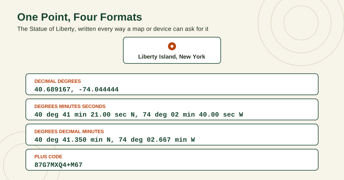
One point shown in four formats: the Statue of Liberty as decimal degrees, degrees minutes seconds, degrees decimal minutes, and a plus code
Method 1: Click the Map on This Page
Use this method when you want every format at once.
Move the map to your area and zoom in until you can see the exact building, gate, or trail junction you mean, not just the neighborhood.
Click the exact spot. The explorer shows the point in decimal degrees, DMS, DDM, and as a plus code.
Copy the form you need with the copy button beside it. Decimal degrees is right for most apps, forms, and messages.
For your own position, use the Use my location button and allow location access when your browser asks.
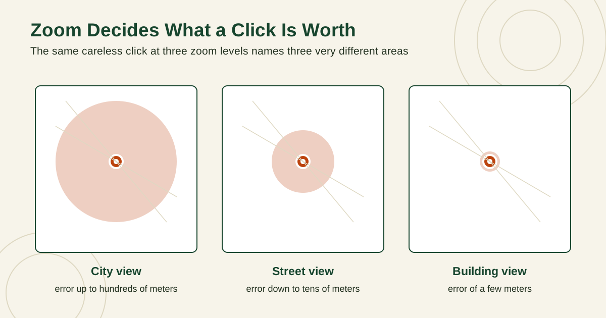
Zoom matters. One degree of latitude is about 111 km, so a careless click at low zoom can be off by hundreds of meters. Zoom in until the feature fills a good part of the screen, then click its center: the roof center for a building, the parking area for a trailhead.
Three map panels at city, street, and building zoom, showing the error circle around a click shrinking from hundreds of meters to a few meters as you zoom in
Method 2: Google Maps on a Phone
Google Maps is the tool most readers already carry, and on a phone it gives coordinates with one gesture.
Open Google Maps and move to the spot. You can search for a place name first, then adjust by dragging the map.
Touch and hold the exact spot until a red pin drops. A panel rises from the bottom of the screen.
Swipe the panel up. The coordinates appear in decimal degrees, usually beside a pin icon, along with the plus code for the same spot.
Tap the coordinates to copy them, or use the Share option in the same panel to send the location directly.
For your own position, tap the blue dot instead: its panel shows the plus code and address, ready to share. If the dot sits in the wrong place or jumps around, see why is my location not accurate.
One warning: press the spot itself, not the name label of a nearby business, which gives you that business entrance instead, possibly across the street from the point you mean.
Method 3: Google Maps on a Computer
On a computer, Google Maps is even quicker: the coordinates are one right-click away.
Open Google Maps in your browser and zoom in on the exact spot.
Right-click the spot. A small menu opens, and the coordinates in decimal degrees sit at the very top of that menu.
Click the coordinates to copy them to your clipboard.
Paste them where you need them, then check the pair once: latitude first, minus signs intact.
If you searched for a named place first, right-click the exact feature rather than trusting the search pin, which can sit tens of meters from the door or trail entrance you care about. See how to drop a pin on Google Maps for more on handling pins well.
Method 4: Apple Maps on iPhone, iPad, and Mac
Apple Maps also shows coordinates, although it hides them one step deeper than Google Maps does.
On an iPhone or iPad:
Open Apple Maps and touch and hold the spot until a pin drops.
Swipe up on the information card for the pin.
Scroll to the bottom of the card. The latitude and longitude appear there in decimal degrees.
On a Mac:
Open Apple Maps and control-click, or right-click, the spot to drop a pin.
Click the information button on the pin card.
Read the latitude and longitude shown in the details.
Apple Maps sometimes shows hemisphere letters instead of signs: 74.044444 W means -74.044444. W and S convert to a minus sign in tools that expect signed decimals, while N and E stay positive. If you switch ecosystems often, Apple Maps vs Google Maps compares the two apps.
Method 5: Get Coordinates From a Photo
Most phone cameras record where each photo was taken, inside the photo file itself. That hidden record is called EXIF data, and it is the fastest way to recover the coordinates of a place you visited but never pinned.
On an iPhone, open the photo in Photos, then swipe up on the image or tap the information button. A small map appears showing where the photo was taken, and tapping the map opens it at full size so you can drop a pin on the exact spot and read the coordinates from there.
On Android, open the photo in Google Photos, swipe up, and look for the location section. If location was recorded, you will see a map preview and an estimated address. Open the map, adjust the pin if needed, and read the pair.
On a computer, photo viewers and file properties panels can show the stored latitude and longitude directly. Prefer those over online EXIF viewers: uploading a personal photo to a random website shares the photo and its location with that site.
Two limits matter. First, a photo only carries coordinates if location access was on for the camera when it was taken. Screenshots never carry them, and many messaging apps strip location out. If the map section is missing, the data is not in that copy, and the original on the photographer's phone is the place to look. Second, think before forwarding your own photos: a holiday photo can quietly contain the exact coordinates of your home.
Method 6: Find Coordinates From an Address
Sometimes you have words instead of a point: a street address, a business name, or a village and a landmark. Turning words into coordinates is called geocoding, and every map search box does it for you.
Geocoding works like this. The map service matches your words against its database of places, picks the best matching point, and places a pin there. That pin's coordinates are the result. Reverse geocoding is the opposite trip: coordinates in, nearest address out.
To geocode an address with the tools in this guide:
Type the full address into Google Maps, Apple Maps, or the search on any map, including the town or city and the postal code if you have them.
Confirm the pin sits on the right building. Addresses can match the wrong town, the wrong street with the same name, or the center of a large property.
Read the coordinates from the pin using the Google Maps or Apple Maps steps above.
Accuracy varies. A geocoded point may mark the center of a land parcel, the driveway entrance, or the middle of the street segment rather than the front door. In a city that is usually a few meters. For rural addresses it can be hundreds of meters, because the database may only know the road, not the house. When precision matters, geocode to get close, then zoom in on satellite view, click the actual building, and use those coordinates instead.
Reading Coordinates Someone Sent You
The reverse task is just as common: someone sends you a pair of numbers, and you need to get to the place, or at least see where it is.
Paste the pair exactly as received into the search box of Google Maps or Apple Maps, or into the Coordinate Explorer above, and the map will jump to the point. Before you travel, run three quick checks:
Order: latitude comes first. Latitude can never be larger than 90 or smaller than minus 90. If the first number is 122 or 151, the pair is almost certainly written longitude first, or it came from a system that lists longitude first. The Sydney Opera House, for example, is -33.856784, 151.215297: the 151 belongs second, as longitude.
Signs: a missing minus sign is the most destructive typo in all of mapping. The pair 40.689167, 74.044444 without the minus sits in Central Asia, not New York Harbor. If a point lands on the wrong continent or in the ocean, a dropped sign or a swapped pair is the likely cause.
Format: if the numbers carry degree, minute, and second symbols, they are not decimal degrees. A string like 87G7MXQ4+M67 is a plus code, searchable directly: see what is a plus code.
Always look at what the map shows after you paste. Does the pin sit in the town and setting the sender described? A trailhead pin should sit on a road end near hills, not in a city block. Ten seconds of looking catches nearly every copy error.
Restyle a Pair Without Retyping It
Sometimes the pair is right but its costume is wrong: a form demands decimal degrees and you were sent degrees, minutes, and seconds, or a boat GPS wants decimal minutes and your phone gave decimals. Retyping invites the dropped minus sign and the swapped pair. Convert instead, and copy the result. The converter below accepts a pair in any of the three formats, or a full plus code, and returns every other form of the same point.
Interactive tool
Coordinate Converter: Restyle Any Pair You Find
Found a pair in one format and need it in another? Paste it here and read the same point in decimal degrees, DMS, DDM, and as a plus code, ready to copy.
From decimal degrees
Degrees minutes seconds40° 41' 21.00" N, 74° 02' 40.00" W
Degrees decimal minutes40° 41.350' N, 74° 02.667' W
Plus code (11 digits)87G7MXQ4+M67
Plus code (10 digits)87G7MXQ4+M6
Your latitude breaks down as 40 degrees, 41 minutes, 21.00 seconds. One degree is 60 minutes, one minute is 60 seconds, so a second of latitude is about 31 meters on the ground.
From degrees minutes seconds
Decimal degrees40.689167, -74.044444
Degrees decimal minutes40° 41.350' N, 74° 02.667' W
Plus code (11 digits)87G7MXQ4+M67
Conversions use the WGS 84 coordinate system, the same one GPS satellites and phone maps use. Plus codes are computed with the open location code algorithm, the same method Google Maps uses.
Which Method Should You Use?
Method
Device
What you get
Coordinate Explorer on this page
Any browser
Decimal, DMS, DDM, and plus code with copy buttons, plus your own location
Google Maps long-press
Android or iPhone
Decimal degrees and a plus code, with sharing built in
Google Maps right-click
Computer
Decimal degrees copied in one click
Apple Maps dropped pin
iPhone, iPad, or Mac
Decimal degrees at the bottom of the pin card
Photo location data
Phone or computer
The coordinates recorded where the photo was taken
Address search (geocoding)
Any map app
Coordinates of the pin that matches the address
Dedicated GPS device
Handheld or car unit
Your current coordinates, in the format the device is set to show
For a single quick lookup, the app on your phone is fine. For repeated work, such as marking field sites or delivery points, the Coordinate Explorer earns its place because it shows every format together, so the number you copy always matches the form or device waiting for it.
Worked Examples to Check Your Method
Practice on points where the answer is known, and your method proves itself.
Statue of Liberty: 40.689167, -74.044444. In DMS that is 40 degrees 41 minutes 21.00 seconds N, 74 degrees 02 minutes 40.00 seconds W. Its full plus code is 87G7MXQ4+M67.
Big Ben, London: 51.500729, -0.124625. Note the small negative longitude: London sits just west of the Prime Meridian.
Eiffel Tower, Paris: 48.858222, 2.2945. Both numbers are positive: north of the equator and east of Greenwich.
Mount Everest: 27.9881, 86.9250. Only four decimal places are shown here, which names an area about 11 m across rather than one exact rock.
More decimal places mean a smaller area. Five places narrow a point to about 1.1 m, while two places only narrow it to about 1.1 km, so copy every digit you were given. Rounding to look tidy can move a meeting point by a full street. The full precision ladder is in latitude and longitude format.
One last test point: 0, 0, where the equator crosses the Prime Meridian in the Atlantic, is nicknamed Null Island. Nothing is there except a weather buoy, but software parks records with missing coordinates there. If a pin lands at 0, 0, the real coordinates never arrived.
One Point in Every Format: A Practice Table
Worked examples are easier to trust when you can test your own method against them. The table below gives eight famous points in all four forms. Cover any column, produce it from the decimal pair with the converter on this page, and check yourself. Every row is the same exercise the methods above perform, with the answer printed.
Place
Decimal degrees
Degrees minutes seconds
Degrees decimal minutes
Plus code
Statue of Liberty, New York
40.689167, -74.044444
40° 41' 21.00" N, 74° 02' 40.00" W
40° 41.350' N, 74° 02.667' W
87G7MXQ4+M67
Big Ben, London
51.500729, -0.124625
51° 30' 02.62" N, 0° 07' 28.65" W
51° 30.044' N, 0° 07.478' W
9C3XGV2G+75R
Eiffel Tower, Paris
48.858222, 2.2945
48° 51' 29.60" N, 2° 17' 40.20" E
48° 51.493' N, 2° 17.670' E
8FW4V75V+7RJ
Sydney Opera House
-33.856784, 151.215297
33° 51' 24.42" S, 151° 12' 55.07" E
33° 51.407' S, 151° 12.918' E
4RRH46V8+74M
Golden Gate Bridge, San Francisco
37.818292, -122.478384
37° 49' 05.85" N, 122° 28' 42.18" W
37° 49.098' N, 122° 28.703' W
849VRG9C+8J9
Colosseum, Rome
41.890942, 12.491903
41° 53' 27.39" N, 12° 29' 30.85" E
41° 53.457' N, 12° 29.514' E
8FHJVFRR+9QC
Taj Mahal, Agra
27.175008, 78.042101
27° 10' 30.03" N, 78° 02' 31.56" E
27° 10.500' N, 78° 02.526' E
7JVW52GR+2R5
Mount Everest
27.9881, 86.9250
27° 59' 17.16" N, 86° 55' 30.00" E
27° 59.286' N, 86° 55.500' E
7MV8XWQG+62R
Compiled for this guide: the decimal coordinates for the Golden Gate Bridge, the Colosseum, and the Taj Mahal were read from OpenStreetMap data on November 19, 2026, and the remaining points are the worked examples used across this site. Every other column was computed from the decimal pair with the same code that powers the converter on this page, whose plus codes pass all 302 official Open Location Code encoding tests.
How Accurate Is the Pair You Just Found?
A coordinate pair looks exact because it is printed with six decimal places, but its real accuracy belongs to the method that produced it, not to the number of digits.
A phone's own GPS fix is the strongest everyday source. The United States government, which operates GPS, states on gps.gov that GPS enabled smartphones are typically accurate to within a 4.9 m (16 ft) radius under open sky, and that the figure worsens near buildings, bridges, and trees. A careful map click at full zoom lands in the same few meter class, because you can see exactly which roof or gate you clicked. A photo's stored coordinates inherit whatever fix the camera had at the shutter moment, good in an open field, poor inside a concrete building. A geocoded address is the roughest of the common methods: exact when the database holds the building, approximate when it only knows the street or the town.
The working rule is to treat every pair as a claim with a radius. When the stakes are real, such as a delivery point, a property corner, or a rescue meeting point, confirm the pair on satellite view, where the roof lines and paths tell you whether the point sits on the right feature, and prefer a pair you clicked on the feature itself over one an address search guessed.
Related Guides
This guide does not stand alone. The coordinates guides below take up the questions it leads into:
How do I find the coordinates of my current location?
Use the Use my location button in the Coordinate Explorer above, or tap the blue dot in Google Maps or Apple Maps. Allow location access when asked, wait a few seconds for the position to settle, then copy the decimal pair shown.
How do I find coordinates without an internet connection?
A phone GPS receiver works without a connection, because it listens to satellites directly. Open a map you downloaded earlier, or a compass app that shows coordinates, and read your position from there. See how to download offline maps before you travel.
What is the difference between GPS coordinates and latitude and longitude?
There is no practical difference for everyday use. GPS is the satellite system that measures your position, and latitude and longitude are the numbers it reports. When people say GPS coordinates, they almost always mean a latitude and longitude pair.
Why do my coordinates land in the wrong place?
The three usual causes are a swapped pair, a dropped minus sign, and a format mix-up, such as typing DMS numbers into a decimal box. Paste the pair into a second map, check latitude first, and confirm each sign before assuming the sender was wrong.
How accurate are phone coordinates?
In open sky, a modern phone usually places you within a few meters. Buildings, cliffs, tree cover, and being indoors can push the error much larger, because the phone falls back on Wi-Fi and cell estimates. The circle around your blue dot is the honest answer for that moment.