An offline map is a chunk of the map saved on your phone, so navigation keeps working when the signal does not: on a rural highway, in a tunnel heavy city, on a flight layover, or anywhere roaming is expensive. Downloading takes about a minute on Wi-Fi. The catch is that you must do it before you lose coverage, and you must know which features go dark offline, because the map that saves your trip is not identical to the online map.
Work through the Offline Trip Checklist: Before You Leave Coverage embedded on this page as you set up, and your phone will be ready before the signal bars disappear.
Interactive tool
Offline Trip Checklist: Before You Leave Coverage
Check off each step as you finish it. Your progress stays on this page.
0 of 8 complete
0% done
What an Offline Map Actually Is
When you download an area, the app stores the road network, place names, and basic place details for that rectangle of the world on your device. Your phone's GPS receiver works without any network at all, since it listens to satellites, not cell towers. Put the two together and you get the essential offline trick: a saved map plus satellite positioning equals navigation with zero connection.
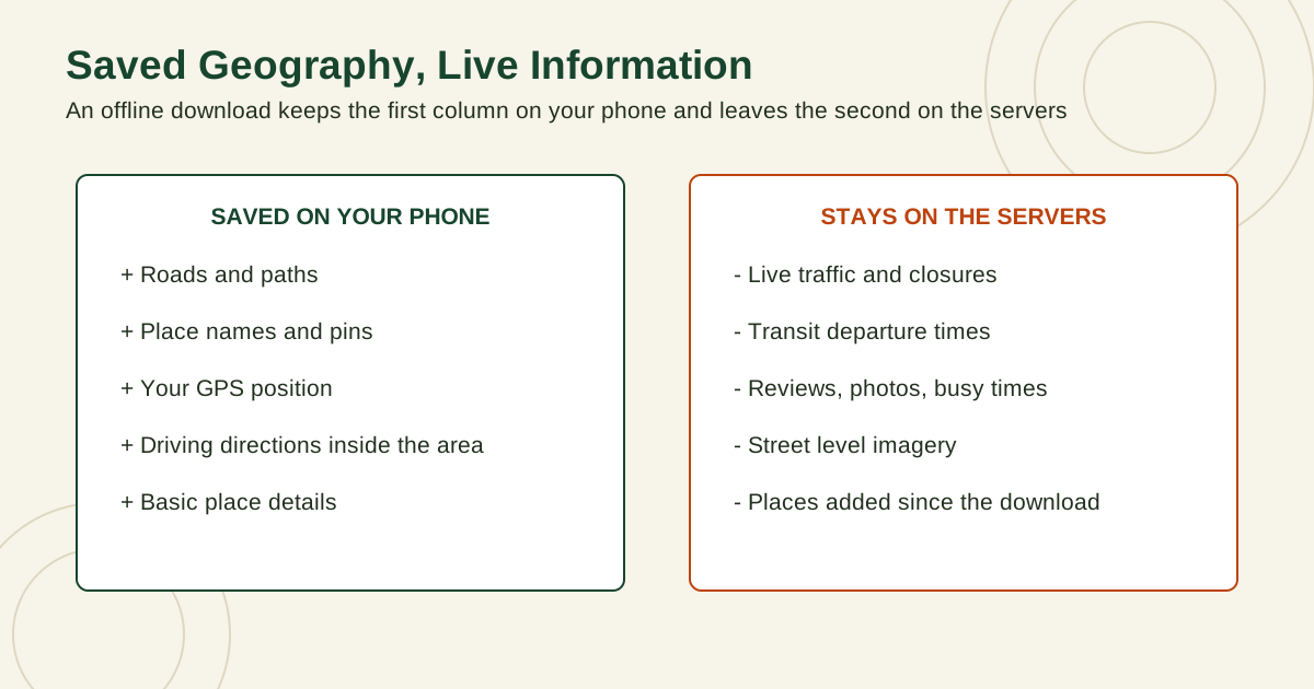
What the download does not contain is anything live. Traffic, closures that happened an hour ago, transit departures, reviews, and photos all live on servers. Understanding that split, saved geography yes, live information no, predicts almost every offline behavior in the table below.
Two columns comparing what an offline download saves on the phone, roads, names, position, and directions, with what stays on the servers, traffic, transit times, reviews, and imagery
Download an Area in Google Maps on Android and iPhone
The steps are the same in Google Maps on Android and on iPhone, and you must be connected to the internet and signed in to Google Maps to download.
The custom rectangle method gives you the most control:
Open Google Maps and tap your profile picture or initial at the top.
Tap Offline maps.
Tap Select your own map.
Pan and zoom the rectangle so it covers the whole area you need: your destination, the full route corridor, and a margin around both. The app shows the download size under the rectangle as you adjust it.
Tap Download and wait for it to finish before closing the app.
The place method is faster for a single city:
Search for the city or place in Google Maps.
Tap the name or address at the bottom to open its place card.
Tap More, then Download offline map, then Download.
Two details decide whether the download actually helps. First, offline driving directions only work when your entire route sits inside the saved area, so draw the rectangle around the route, not just the destination city. A trip between two cities needs one generous rectangle or two overlapping downloads. Second, check the size before you commit. A compact city area is small; a wide region with dense streets is much larger. If storage is tight, shrink the rectangle to the corridor you will really drive, and delete old downloads from places you will not revisit.
On Android, you can also choose where downloads live. In the Offline maps screen, open the settings or Download preferences and choose between the device and an SD card set up as portable storage, which is useful on phones with small internal storage. Changing that setting later means downloading the areas again, so set it before a big trip, not during one.
Download an Area in Apple Maps on iPhone
Apple Maps offers offline maps on iPhone running a recent version of iOS that includes the feature. If you do not see the options below, update iOS first.
Open Apple Maps and tap your picture or initials.
Tap Offline Maps.
Tap the option to add or download a new map, then search for the place or use Current Location.
Adjust the rectangle to cover the area you need. The app shows the file size before you download.
Tap Download.
You can also start from the map itself: touch and hold a spot until a pin appears, then tap Download on its card to save the area around it.
Apple Maps offline maps stay on the device you downloaded them to and do not sync to your other devices, so download on the phone you will actually carry. The same is true in Google Maps in practice: set up each travel phone separately, including your partner's, because a perfect download on the wrong phone helps nobody at the trailhead.
What Works Offline and What Does Not
Feature
Google Maps offline
Apple Maps offline
Notes
View the map and zoom
Yes
Yes
Only inside the downloaded area
Your GPS position on the map
Yes
Yes
GPS needs no network, but works best with a clear view of the sky
Driving directions
Yes, inside the area
Yes
The whole route must be inside the saved area
Walking and cycling directions
Limited, do not rely on them
Yes, in the saved area
Test your exact route in airplane mode before you go
Transit directions
No
Yes, in the saved area, without live times
Departures offline are scheduled data, not live arrivals
Live traffic and rerouting around jams
No
No
Offline routing cannot see current conditions
Alternate routes based on conditions
No
No
You get routes from saved roads only
Search for places
Saved area only, basic details
Saved area only, with saved details such as hours and ratings
New or niche places may be missing
Reviews, photos, busy times
No
No
These are live server data
Street level imagery
No
No
Imagery is far too large to download
Read the table as a planning tool. If your trip depends on transit, Apple Maps offline covers you better, and Google Maps users should screenshot key transit routes while online as a backup. If your trip depends on avoiding traffic, no offline map can help; your defense is timing, leaving before the rush, not software.
Size the Download to the Route, Not the Destination
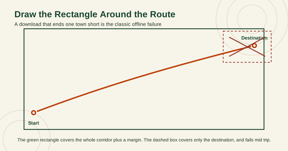
The most common offline failure is a rectangle drawn around the destination city while the drive itself crosses two hundred kilometers of unsaved countryside. Downloads are rectangles, and directions work only where the rectangle reaches, so plan the shape around the corridor you will actually travel: start point, route, detours, and destination, with a margin on every side.
A route line crossing a map, covered by one large green rectangle with a margin, beside a small dashed rectangle around the destination alone, marked as the failing choice
The table below sizes six familiar trips. Distances are straight line distances between city centers, computed for this guide with the same great circle method our distance tool uses, the method checked against published reference values in our tool testing. Roads always run longer than the straight line, and they wander sideways too, which is exactly why the rectangle needs its margin.
Trip
Straight line distance
Download advice
New York to Boston
306 km (190 mi)
One rectangle holds both cities and the corridor between them
London to Paris
344 km (213 mi)
One rectangle, downloaded before you leave, on both phones if you travel as a pair
Los Angeles to Las Vegas
367 km (228 mi)
One wide rectangle along the corridor, not two city boxes
San Francisco to Los Angeles
560 km (348 mi)
One generous rectangle, or two overlapping ones split at the midpoint
Denver to Salt Lake City
597 km (371 mi)
Two overlapping rectangles, one per half, so a failed update cannot strand you
Sydney to Melbourne
713 km (443 mi)
Two or three rectangles, one per driving day, each updated before departure
Measure your own trip the same way before you draw anything. Click your start, your destination, and the places you might detour to, and the tool returns the corridor length your downloads must cover.
Interactive map
Distance Measurer: Size the Corridor Your Download Must Cover
Click your start and end points, then the places you will detour to. The total line is the corridor your offline rectangle has to contain, with room to spare.
If the total line approaches the Sydney to Melbourne class, stop trying to hold the trip in one rectangle. Split it by driving day, and treat each leg as its own download with its own expiry check in the pre trip routine below.
Expiry and Auto Update: The Silent Failure
Downloaded Google Maps areas expire. They are not permanent copies, and an area you saved months ago for a return trip may refuse to navigate or may have been removed. Google Maps tries to rescue you: when an offline area is within 15 days of expiring and your phone is on Wi-Fi, the app tries to update it automatically. You can also turn on Auto update offline maps in the Offline maps settings so areas refresh on their own, and you can update any single area manually from the Offline maps list with its update option.
Do not rely on the rescue. The automatic update only happens if the phone is on Wi-Fi during that window, with the app in good standing, which travel phones in drawers often are not. The reliable habit is in the checklist below: reopen your downloads a few days before every trip, update them on home Wi-Fi, and confirm each one still covers your route.
Apple Maps downloads do not expire on the same schedule, but they go stale in the same way: roads change, businesses close, and a year old download quietly lacks the new bypass everyone else is using. Refresh before travel there too.
Data and Battery Tactics for Offline Trips
Offline maps save data, but only if you finish the setup on Wi-Fi. Downloading a large area on cellular burns exactly the data you were trying to save, so do every download at home or on hotel Wi-Fi, and keep the default that prefers Wi-Fi for downloads.
Once offline, your battery becomes the scarce resource. Navigation with the screen on is one of the heaviest loads a phone carries. Practical tactics that work:
Start the day at a full charge and carry a power bank for any drive or hike longer than a couple of hours.
Download the map, then navigate with the screen off where voice guidance is enough, waking the screen for complex interchanges.
Keep Location on, since GPS is the whole point, but close other heavy apps competing for power.
If your location starts drifting or freezing offline, check that power saving mode is not throttling location updates; our guide on why your location is not accurate explains that tradeoff in detail.
In a car, use a charger. Offline navigation plus a hot dashboard can drain a phone faster than a weak charger refills it.
Roaming deserves one sentence: an offline map removes your need for data, but your phone may still roam for calls and background sync. If your goal is zero roaming charges, airplane mode with Wi-Fi and Bluetooth toggled as needed is the strict setting, and your offline map works fine inside it because GPS stays live in airplane mode on most phones.
The Other School: Apps Built Offline From the Start
Google Maps and Apple Maps treat offline as a mode. A second family of apps treats it as the design. OsmAnd and Organic Maps are built on OpenStreetMap data, the same open map data this site explains, and they download whole regions or countries as files. Search, place details, and routing for driving, cycling, and walking then work entirely on the device, with no rectangle to draw and no corridor math to do.
App
Map data
Download unit
Routing that works offline
Built in live traffic
Google Maps
Google
A rectangle you draw
Driving
No
Apple Maps
Apple
A rectangle you draw
Driving, walking, cycling, scheduled transit
No
OsmAnd
OpenStreetMap
A region or country file
Driving, cycling, walking, and more
No
Organic Maps
OpenStreetMap
A region or country file
Driving, cycling, walking
No
The trade is freshness and polish. A region file is only as new as your last update, the search feels different from the big apps, and no offline app of any school can show live traffic. In exchange you get the whole country in your pocket, trails and paths the road focused apps often lack, and a setup that cannot fail because a rectangle ended one town short. Hikers, overland travelers, and anyone crossing several countries on one trip are the natural audience, and the pre trip routine below still applies: update the files, then prove the route in airplane mode.
The Pre Trip Routine: Test It Before It Matters
Do this routine two or three days before departure, then repeat the airplane mode test the night before.
Connect to home Wi-Fi and open your map app's Offline maps screen.
Download or update the areas for every leg of the trip, including the airport area and the drive from it, not just the destination.
Save the key places inside the app while online: hotel, trailhead, station, the dropped pin for anything without an address.
Turn on airplane mode.
Request driving directions from your arrival point to your hotel, and scroll the whole route on the map.
Turn airplane mode off and fix anything that failed: enlarge the rectangle, download the missing leg, save the missing place.
That five minute test is the difference between a system and a hope. It catches the classic failures while you still have Wi-Fi: the rectangle that ends one town short, the expired download from last season, the hotel saved in the other app. If you are still choosing your primary app for the trip, our comparison of Apple Maps vs Google Maps covers which one behaves better abroad. For more trip preparation, browse the GPS and navigation guides.
Related Guides
The closest companions to this guide are the GPS and navigation guides below. Each one picks up a thread this page starts:
They expire and must be updated, and the app will try to update an area automatically when it is within 15 days of expiring and you are connected to Wi-Fi. Turn on Auto update offline maps in the Offline maps settings to let this happen without thinking, and still check your downloads manually a few days before any trip that depends on them.
Why is there no Download option for my destination?
Offline downloads are not available in some countries and regions because of licensing, language, or address format limits. If the option is missing for your destination, try the custom rectangle method from the Offline maps screen, and if it is still unavailable, plan on screenshots of key routes, a saved list of places, and a local SIM or eSIM for data instead.
Can I navigate offline with airplane mode on?
Yes. GPS positioning works in airplane mode on most phones because the GPS receiver is separate from the cellular radio. Download your area first, then enable airplane mode and request directions inside the saved area to prove it works. This airplane mode test is the core of the pre trip routine in this guide.
How much storage does an offline map need?
It depends on the size of the rectangle and the density of roads and places inside it, and both Google Maps and Apple Maps show you the exact size before you confirm the download. A single neighborhood is small, a whole metro area is much larger, and a multi city corridor is larger still. Check the number on screen, and delete downloads from finished trips to keep space free.
Do offline maps work for transit and walking?
In Apple Maps, downloaded areas include directions for driving, walking, cycling, and transit, without live departure times. In Google Maps, offline mode is built around driving: transit directions are unavailable offline, and walking and cycling support is limited, so transit riders on Google Maps should save screenshots of their routes while online as a backup.