The same point on Earth can be written three different ways, and the three versions look like three different places. They are not. They are three notations for one latitude and one longitude, and once you can read all three, no map, GPS device, or chart can lock you out. This article teaches each format, shows which systems use which, and walks through a full conversion by hand.
The quick way to see all three side by side is the Coordinate Converter on this page: type decimal degrees or DMS and it returns every other format live, so you can check any example below as you read.
Interactive tool
Coordinate Converter
Convert latitude and longitude between decimal degrees, degrees minutes seconds, degrees decimal minutes, and plus codes. Everything updates as you type.
From decimal degrees
Degrees minutes seconds40° 41' 21.00" N, 74° 02' 40.00" W
Degrees decimal minutes40° 41.350' N, 74° 02.667' W
Plus code (11 digits)87G7MXQ4+M67
Plus code (10 digits)87G7MXQ4+M6
Your latitude breaks down as 40 degrees, 41 minutes, 21.00 seconds. One degree is 60 minutes, one minute is 60 seconds, so a second of latitude is about 31 meters on the ground.
From degrees minutes seconds
Decimal degrees40.689167, -74.044444
Degrees decimal minutes40° 41.350' N, 74° 02.667' W
Plus code (11 digits)87G7MXQ4+M67
Conversions use the WGS 84 coordinate system, the same one GPS satellites and phone maps use. Plus codes are computed with the open location code algorithm, the same method Google Maps uses.
The One Point Used Throughout This Article
Every example in this article uses the Statue of Liberty, so you can compare formats without wondering whether the place changed.
Decimal degrees: 40.689167, -74.044444
Degrees decimal minutes: 40 degrees 41.350 minutes N, 74 degrees 2.667 minutes W
Degrees minutes seconds: 40 degrees 41 minutes 21.00 seconds N, 74 degrees 02 minutes 40.00 seconds W
Same statue, same patch of harbor, three costumes. The latitude is about 40.69 degrees north of the equator in every version, and the longitude is about 74.04 degrees west of Greenwich in every version. Only the way the fractional part is sliced up changes.
Format 1: Decimal Degrees
Decimal degrees, often shortened to DD, writes each coordinate as a single number with a decimal fraction: 40.689167 and -74.044444. The whole number part is degrees. Everything after the decimal point is a fraction of one degree, carried as far as the precision requires.
This is the format of the digital world. Google Maps shows it, phones store it, spreadsheets and databases hold it, and web addresses carry it. When a form, app, or device asks for coordinates without specifying a format, decimal degrees is the safest bet.
Read it aloud as two plain numbers: "forty point six eight nine one six seven, minus seventy-four point zero four four four four four." Say the minus sign every time: a spoken longitude that loses it sends the listener to the wrong side of the planet.
Signs do the work that hemisphere letters do in the other formats. Positive latitude means north, negative means south. Positive longitude means east of Greenwich, negative means west. The sign is not decoration. It is half the information.
Format 2: Degrees Decimal Minutes
Degrees decimal minutes, shortened to DDM, splits each coordinate into whole degrees plus minutes carried as a decimal: 40 degrees 41.350 minutes N. One degree contains 60 minutes, so the minutes value always falls between 0 and 60, here 41.350. The fraction lives in the minutes instead of in the degrees.
You will meet DDM on water, in the air, and on many handheld GPS units. Marine and aviation systems favor it for a practical reason: one minute of latitude equals one nautical mile, 1.852 km, everywhere on Earth, so a navigator can think directly in nautical miles from a chart line.
Read it aloud in pieces: "forty degrees, forty-one point three five zero minutes north." The hemisphere letter is spoken at the end of each coordinate, and it replaces the sign. In DDM you write N, S, E, or W and drop the minus sign. Writing both, such as minus 74 degrees W, double-counts the direction and confuses some devices, so pick one system per pair: signs with decimal degrees, letters with DDM and DMS.
Format 3: Degrees Minutes Seconds
Degrees minutes seconds, shortened to DMS, is the oldest of the three and the one printed on paper maps for generations. It splits each coordinate into degrees, whole minutes, and seconds, which can themselves carry a decimal: 40 degrees 41 minutes 21.00 seconds N. One degree holds 60 minutes, and one minute holds 60 seconds, so a full degree holds 3,600 seconds.
Surveying, older topographic maps, legal land descriptions, and textbooks still use DMS, as do some camera displays and government records. The symbols are standard: a small circle for degrees, a single mark for minutes, and a double mark for seconds. In plain text it also appears with spaces and letters, such as 40 41 21.00 N.
Read it aloud fully: "forty degrees, forty-one minutes, twenty-one seconds north, seventy-four degrees, two minutes, forty seconds west." It is the longest to say, which is one reason marine practice prefers DDM, but it is exact and still everywhere. If you are learning paper maps seriously, how to read a topographic map builds on this format.
Which Systems Use Which Format
Format
Where you will meet it
Example for one point
Decimal degrees (DD)
Google Maps, phones, web maps, databases
40.689167, -74.044444
Degrees decimal minutes (DDM)
Marine and aviation navigation, handheld GPS units
40 degrees 41.350 minutes N, 74 degrees 2.667 minutes W
Degrees minutes seconds (DMS)
Surveying, older maps, textbooks, land records
40 degrees 41 minutes 21.00 seconds N, 74 degrees 02 minutes 40.00 seconds W
The practical rule is to match the system in front of you. If a chart or survey document gives DMS, work in DMS until the job is done. If an app wants a paste, give it decimal degrees. Every conversion is a chance to mistype a digit, so convert once, at the end, and then verify.
Order: Latitude First, and the Swap Error
In the latitude and longitude system, latitude always comes first. The pair is latitude, comma, longitude. This surprises people who learned x, y coordinates in school, where the horizontal value comes first, because longitude is the horizontal, east to west measurement. Maps made the opposite choice, and the whole world follows it: latitude first.
The swap error is the single most common coordinate mistake. Swap the Statue of Liberty pair and you get -74.044444, 40.689167, which claims a latitude of minus 74, deep in the southern ocean near Antarctica. Sometimes a swap is obvious like that. Sometimes it is not: swapping a pair where both numbers are under 90 produces a valid looking point in the wrong country, and the map accepts it without complaint.
Use two checks to catch swaps. First, latitude can never exceed 90. If the first number in a pair is 122, 151, or 139, it cannot be a latitude, so the pair is reversed or mislabeled. The Sydney Opera House is -33.856784, 151.215297, and the 151 gives the game away instantly. Second, ask whether the point lands where you expect. Big Ben in London is 51.500729, -0.124625. Swapped, it would sit far south in the Indian Ocean. If a pasted pair lands in an ocean or on the wrong continent, suspect a swap or a dropped minus sign before you suspect the sender. Our guide to how to find coordinates shows how to test a received pair on a map.
Hemisphere Letters Versus Minus Signs
Both systems say the same thing, and fluency means translating between them without thinking.
N means north: positive latitude. S means south: negative latitude.
E means east: positive longitude. W means west: negative longitude.
So 33.856784 S becomes -33.856784, and 2.2945 E stays 2.2945, which is the longitude of the Eiffel Tower in Paris, at 48.858222, 2.2945. The equator and the Prime Meridian themselves are zero in both systems, neither positive nor negative, and the famous crossing point at 0, 0 in the Atlantic is nicknamed Null Island.
Latitude runs from minus 90 at the South Pole to 90 at the North Pole. Longitude runs from minus 180 to 180, and those two extremes are the same line, opposite Greenwich. Any number outside those ranges is not a coordinate in this system at all.
Precision: What Each Decimal Place Is Worth
In decimal degrees, each extra decimal place shrinks the area you are naming by a factor of ten. Because one degree of latitude is about 111 km everywhere, the ladder is easy to remember.
Decimal places
Step size in degrees
Approximate ground distance
0
1 degree
111 km
1
0.1 degrees
About 11 km
2
0.01 degrees
About 1.1 km
3
0.001 degrees
About 111 m
4
0.0001 degrees
About 11 m
5
0.00001 degrees
About 1.1 m
6
0.000001 degrees
About 0.11 m
Read the table as a guide to how many digits a job needs. Two places find a town, three a neighborhood, four, as in Mount Everest at 27.9881, 86.9250, a feature about 11 m across, and five a building entrance. Six claim about 11 cm, which most phones cannot deliver, so treat a sixth place as storage detail rather than truth.
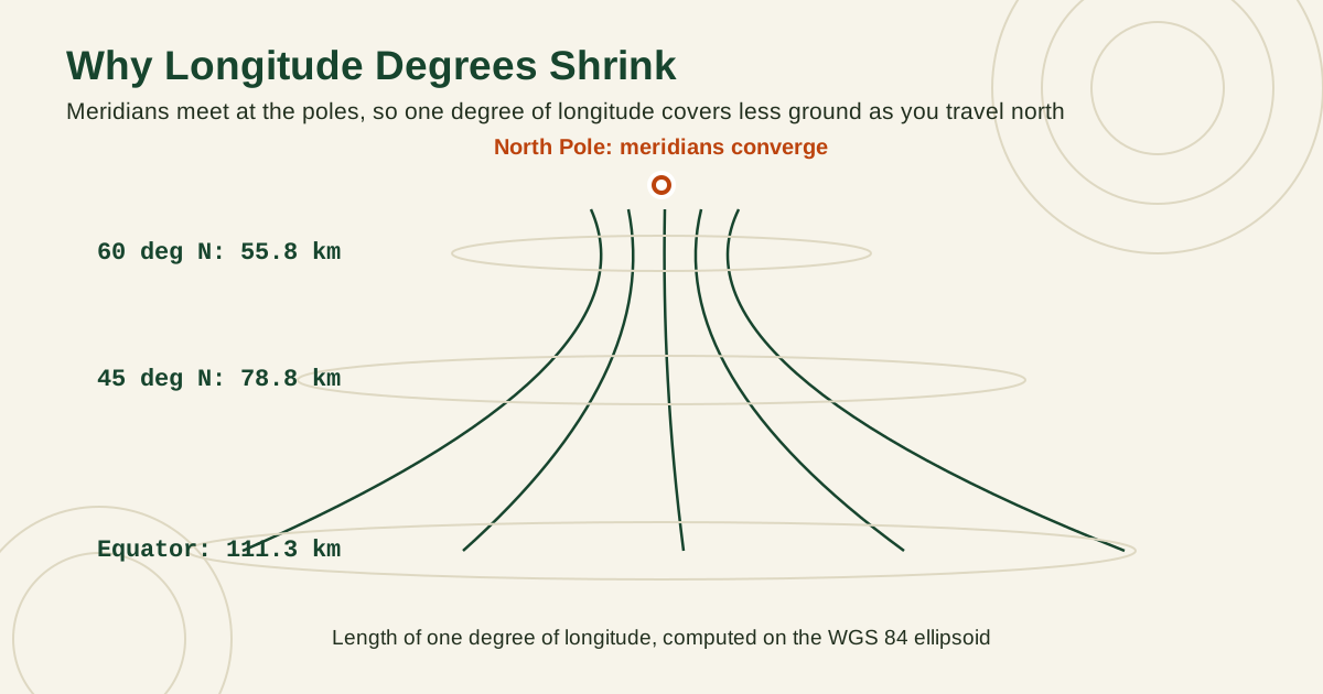
Longitude degrees shrink as you leave the equator, because the lines of longitude converge toward the poles. One degree of longitude is about 111 km at the equator, about 85 km at 40 degrees latitude, and about 56 km at 60 degrees latitude. The latitude ladder above stays constant, which is why navigators love latitude minutes: one minute of latitude is one nautical mile, 1.852 km, and one second of latitude is about 31 m, anywhere on the planet.
The lesson for everyday sharing is simple. Copy all the digits you were given, and do not round to make a pair look neat. Rounding 40.689167 to 40.69 moves the point by roughly 90 m, from the statue to somewhere in the harbor water.
How Long Is a Degree Where You Stand?
The ladder above treats a degree of latitude as about 111 km everywhere, which is close enough for sharing. The exact lengths are more interesting, because Earth is not a perfect sphere. It bulges slightly at the equator, and the reference shape used by GPS, the WGS 84 ellipsoid, lets us compute exactly how long a degree is at any latitude. The table below was computed for this guide from the WGS 84 parameters published by the US National Geospatial-Intelligence Agency (semi-major axis 6,378,137 m, flattening 1/298.257223563).
Latitude
One degree of latitude
One degree of longitude
One minute of latitude
0 degrees (equator)
110.574 km
111.319 km
1,843 m
15 degrees
110.649 km
107.550 km
1,844 m
30 degrees
110.852 km
96.486 km
1,848 m
45 degrees
111.132 km
78.847 km
1,852 m
60 degrees
111.412 km
55.800 km
1,857 m
75 degrees
111.618 km
28.902 km
1,860 m
Read the two degree columns against each other. A degree of latitude barely changes, growing by about one kilometer between the equator and the high north, because you are always walking along the same gently curving surface. A degree of longitude collapses, from 111.319 km at the equator to under 29 km at 75 degrees, because the meridians converge toward the poles and the same angular step covers less and less ground.
The last column explains a famous coincidence. One minute of latitude stays between 1,843 m and 1,860 m everywhere, always within about half a percent of 1,852 m, which is exactly one nautical mile by modern definition. At 45 degrees latitude the match is nearly perfect. That is why the sailor's rule, one minute of latitude equals one nautical mile, works on every ocean: latitude minutes are the one unit in this whole system that means the same distance almost everywhere on the planet.
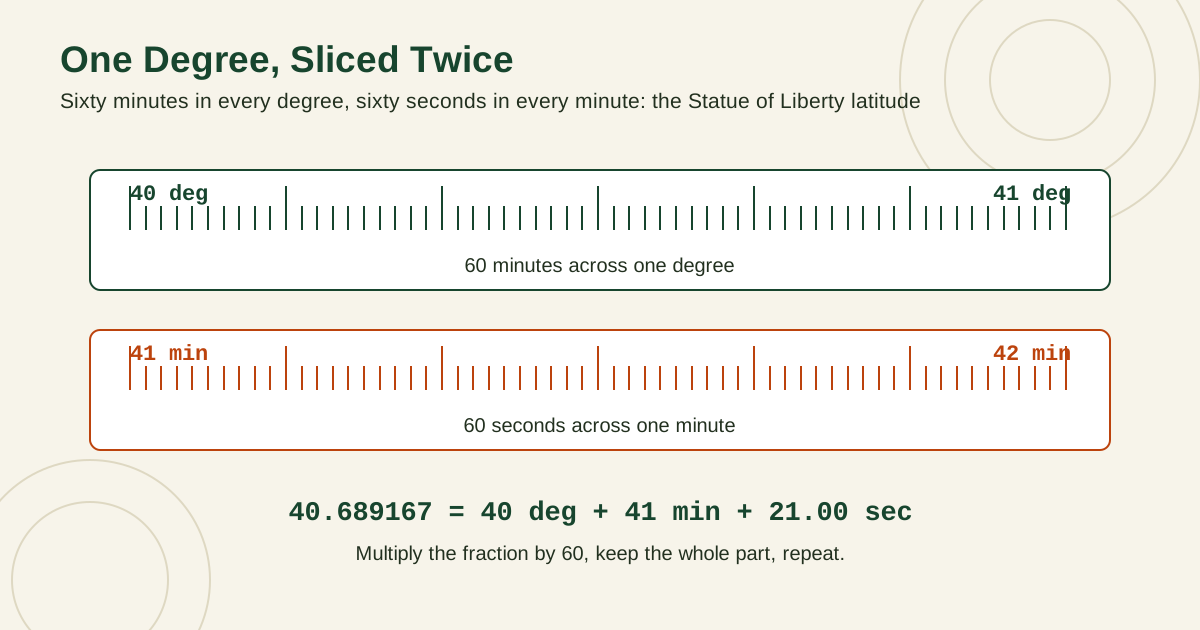
Meridian lines converging toward the North Pole, with the length of one degree of longitude labeled at the equator, 45 degrees north, and 60 degrees northA degree bar divided into 60 minutes and a minute bar divided into 60 seconds, working the Statue of Liberty latitude from 40.689167 into degrees, minutes, and seconds
Converting by Hand: The Multiply and Divide by 60 Method
Conversion between the formats is only multiplication and division by 60, because minutes and seconds are sixtieths. Work one coordinate at a time.
Decimal degrees to DMS
Take the latitude 40.689167.
Keep the whole degrees: 40 degrees. Work with the fraction, 0.689167.
Multiply the fraction by 60: 0.689167 times 60 equals 41.35002. Keep the whole minutes: 41 minutes. Work with the new fraction, 0.35002.
Multiply that fraction by 60: 0.35002 times 60 equals 21.0012, which rounds to 21.00 seconds.
Add the hemisphere: the original latitude is positive, so it is N. Result: 40 degrees 41 minutes 21.00 seconds N.
Now the longitude, -74.044444.
Keep the whole degrees: 74 degrees. Ignore the minus sign for the arithmetic and restore it as a letter at the end.
Multiply 0.044444 by 60: that gives 2.66664. Keep 2 minutes, fraction 0.66664.
Multiply 0.66664 by 60: that gives 39.9984, which rounds to 40.00 seconds.
The original sign was negative, and negative longitude is west. Result: 74 degrees 02 minutes 40.00 seconds W.
Stopping after step 2 of each conversion gives you DDM instead: 40 degrees 41.350 minutes N and 74 degrees 2.667 minutes W. One method serves both formats.
DMS to decimal degrees
Run the machine in reverse. Take 40 degrees 41 minutes 21.00 seconds N.
Divide the seconds by 60: 21.00 divided by 60 equals 0.35. Add it to the minutes: 41 plus 0.35 equals 41.35 minutes.
Divide the minutes by 60: 41.35 divided by 60 equals 0.689167, rounded to six places.
Add the degrees: 40 plus 0.689167 equals 40.689167. N is positive, so no sign change.
For the longitude, 74 degrees 02 minutes 40.00 seconds W: 40.00 divided by 60 equals 0.6667, added to 2 minutes gives 2.6667 minutes, divided by 60 gives 0.044444, added to 74 gives 74.044444, and W makes it negative: -74.044444. The full circle is closed, back at the decimal pair we started with.
By hand is how you learn it, but for daily work, paste the pair into the Coordinate Converter above or into the explorer described in how to find coordinates, and let the tool do the arithmetic while you do the checking.
See the Point Behind the Numbers
Formats are easier to trust once you have watched one point wear all three at once. The explorer below takes a typed pair in any format, or a click on the map, and shows the spot on a live map while its decimal, DDM, DMS, and plus code forms update together. Convert a pair from this article, then find the same point on the map and confirm the pin sits where the numbers promised.
Interactive map
Coordinate Explorer: See the Point Behind the Numbers
Type a pair in any format, or click the map, and watch the same spot appear on a live map while every format updates together.
Decimal degrees40.689167, -74.044444
Latitude40.689167° N
Longitude74.044444° W
Degrees minutes seconds40° 41' 21.00" N, 74° 02' 40.00" W
Degrees decimal minutes40° 41.350' N, 74° 02.667' W
Three errors account for nearly every bad coordinate: the swap (latitude first, always), the dropped minus sign (speak signs aloud, and copy rather than retype), and mixing formats mid-pair, such as pasting a DMS value into a box that expects decimals. A value like 40 41 21 typed as 40.4121 looks plausible and is simply wrong, off by kilometers. If a device rejects a pair, check its position format setting before you check the numbers: most GPS units offer exactly these three choices, and a mismatch explains many mysteries blamed on accuracy in why is my location not accurate.
Related Guides
The closest companions to this guide are the coordinates guides below. Each one picks up a thread this page starts:
Use decimal degrees for phones, web maps, apps, and sharing with most people. Use DDM if your boat, aircraft, or handheld GPS is set to it. Use DMS when a paper map, survey, or document you are working from uses it. Matching the system in front of you beats converting everything.
How do I read coordinates aloud correctly?
Read each number completely, including the word minus for negative values, and pause at the comma. In DDM and DMS, read the degrees, minutes, and seconds in order and finish each coordinate with its hemisphere letter, such as north or west.
Why does my GPS show a different format than Google Maps?
Because its position format setting differs. Google Maps uses decimal degrees. Many GPS units ship set to DDM, and survey and marine gear often uses DMS. All three describe the same point, and you can change the setting in the device menu or convert with the tool on this page.
How many decimal places do I need?
Four decimal places place you within about 11 m, which is enough for a building or a trailhead. Five places reach about 1.1 m, enough for an entrance or a parked car. More places than six add no real accuracy for consumer devices.
What do I do if a coordinate has letters instead of minus signs?
Translate the letters: N and E are positive, S and W are negative. Then write the pair as signed decimal degrees, latitude first. For example, 33.856784 S, 151.215297 E becomes -33.856784, 151.215297.